


لاحظ الملاحون نظرا لإرتحالهم الدائم؛تباين مواقيت الصلاة من ميناء لأخرخاصة إذا إختلف خط العرض بقيمة كبيرة ولاحظ المسلمون عموما إختلاف مواقيت الصلاة فى نفس الموقع على مدار السنة حقيقة الأمر أن ميقات الصلاة يتوقف على كل من :
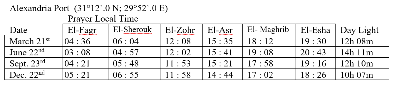
ولتوضيح االفرق فى مواقيت الصلوات فى نفس الموقع نبين فى الجدول التالى مواقيت الصلاة فى ميناء الأسكندرية ( جمهورية مصر العربية) فى أيام الإعتدال الربيعى ( 21 مارس ) ؛ الإنقلاب الصيفى (22 يونية ) ؛ الإعتدال الخريفى ( 23 سبتمبر ) والإنقلاب الشتوى (22 ديسمبر ) .
ولتوضيح االفرق فى مواقيت الصلوات فى مواقع مختلفة ذات خطوط عرض متزايدة شمالا نبين فى الجدول التالى مواقيت الصلاة فى الإعتدالين و الإنقلابين فى ثلاث موانئ متزايدة خط العرض
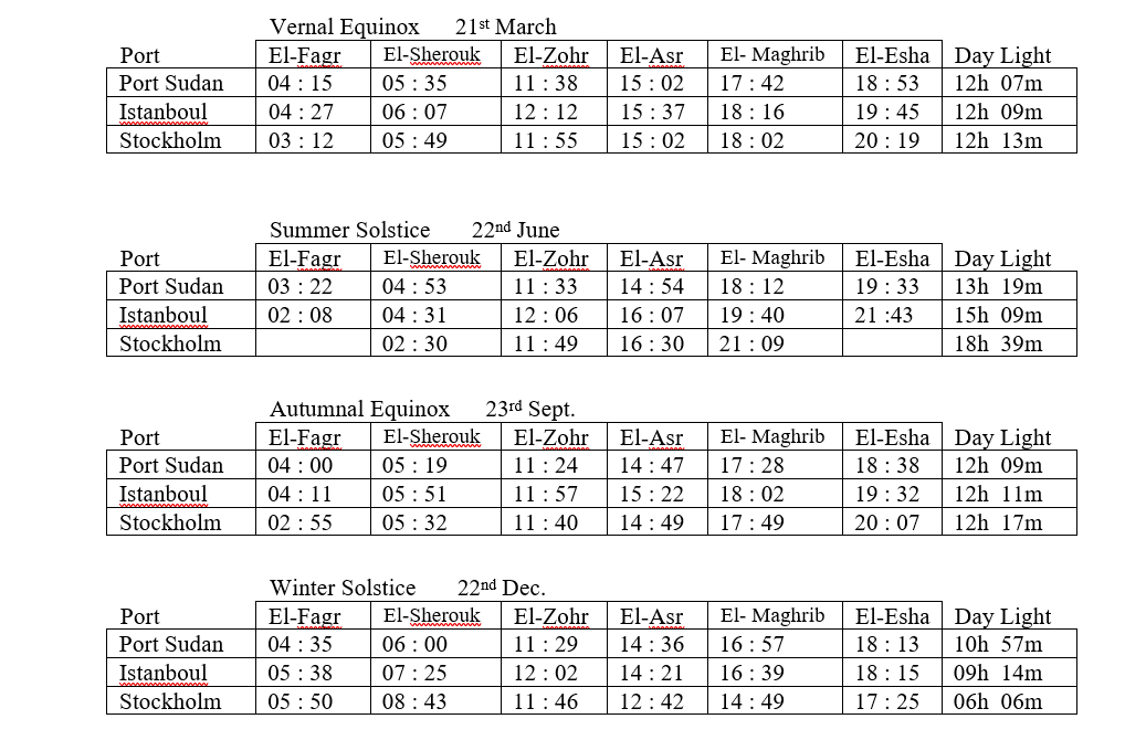
نلاحظ أنه لايوجد ميقات صلاة لكل من الفجر و العشاء فى ميناء ستوكهولم يوم 22 يونية وتفسير ذلك أن الشرط الشرعى لهذين الميقاتين غير متوافر؛ كما سنرى. نلاحظ أيضا التباين الشديد فى أوقات الصلاة مع تغير خط العرض ؛ حيث:
يوجد العديد من البرامج الخاصة بتحديد مواقيت الصلاة للمسلمين فى مواقع محددة وحتى مستوى المدن الصغيرة فى كافة دول العالم ولكن بالنسبة للسفن المبحرة فى أعالى البحار والتى تتغير مواقعها بإستمرار فإن الملاح يلجأ لحساب مواقيت الصلاة وكذلك إتجاه القبلة بإستخدام حساب المثلثات الكروية ومعتمدا طريقة الحساب المتتالى وقد لاحظ المؤلف بمناقشة الإخوة الضباط الملاحين ،أن طريقة الحساب لبعضهم تختلف كثيرا عن التعريف الشرعى لميقات كل من صلاة الفجر ، صلاة العصر وكذلك صلاة العشاء.
من ثم ، وبمساعدة السيد المهندس / إسلام بدوى ؛ تم تصميم برنامج لحساب مواقيت الصلوات وكذلك إتجاه القبلة للسفن المبحرة طبقا للتعريف الشرعى لميقات كل صلاة وبناءا على ماهو منشور فى الكتاب السنوى لهيئة المساحة المصرية والخاص بمواقيت الصلاة فى جمهورية مصر العربية.
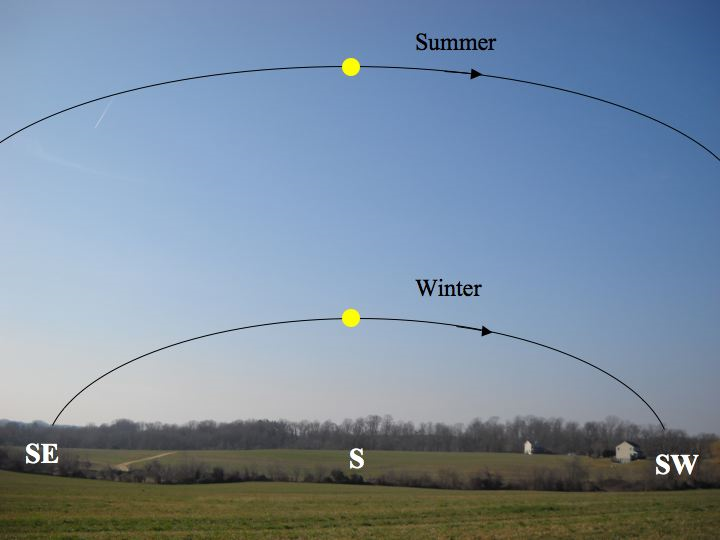
يرتبط التعريف الشرعى لمواقيت الصلاة بالمواقع الظاهرية للشمس على سطح الكرة السماوية. ومن البديهى أن الشمس تدور ظاهريا حول الأرض
( كنتيجة عكسية لدوران الأرض حول محورها ) دورة كاملة فى فترة زمنية متغيرة تسمى اليوم الشمسى الظاهرى (Apparent Solar Day) ولذلك فلحساب ميقات صلاة ما فى موقع ما فاننا نحسب أولا الموقع الظاهرى للشمس طبقا للتعريف الشرعى معبرا عنه بقيمة Local Hour Angle ومن ثم نحسب الوقت الشمسى الظاهرى المناظر وأخيرا يتم تحويله الى الوقت الشمسى المتوسط
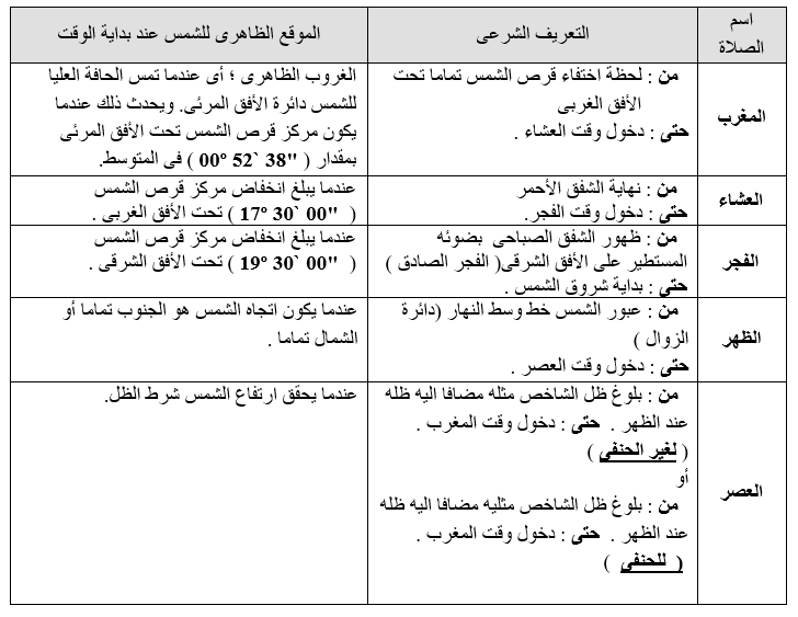
فيما يلى التعريف الشرعى لمواقيت الصلاة يقابله الوضع الظاهرى للشمس فى بداية الوقت طبقا لما جاء فى الكتاب السنوى لهيئة المساحة المصرية والخاص بمواقيت الصلاة فى جمهورية مصر العربية
يخضع الأساس الرياضى لتحديد اتجاه القبلة ( الكعبة المشرفة ) من أى موقع على سطح الأرض لمبادىء حسابات الأبحار على الدائرة العظمى .
فاذا فرضنا أن موقع مكة المكرمة هو M وأن موقع الراصد هو N فان اتجاه مكة المكرمة من الموقع N يكون هو خط السير الأبتدائى ( فرضا ) لمسار الدائرة العظمى من الموقع N الى الموقع M .
تم تصميم البرنامج الحالى لإيجاد الإتجاه الحقيقى للقبلة على هذا الأساس الرياضى حيث موقع مكة المكرمة هو . (21º 25`.3 N; 39º 49`.5 E)
قم بتطبيقه الآن
وتطبق لأى جرم سماوى يكون منخفض الإرتفاع ( أقل من 15°) وفى الظروف الإستثنائية حتى (35°) وذلك لتجنب إسقاط إتجاه الجرم على مرآة العزيمة. بالنسبة للإرتفاعات الأكبريكون خطأ البوصلة غير معتمد الشكل التالى يوضح تسلسل الحل بطريقة الوقت والتى تم على أساسها تصميم البرنامج.
قم بتطبيقه الآن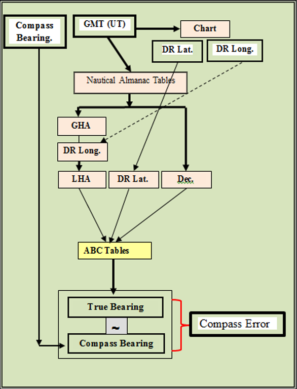
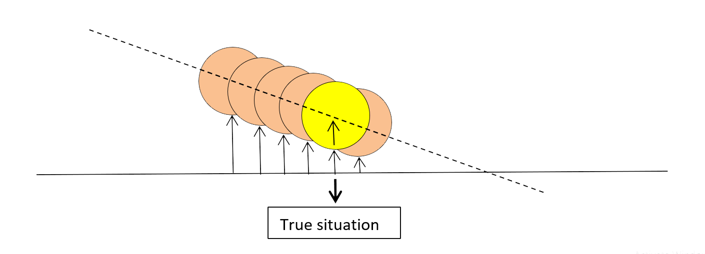
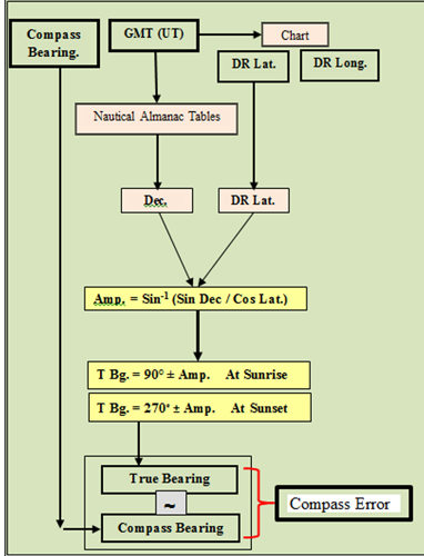
الطريقة الثانية تستخدم أثناء شروق أو غروب الشمس النظرى ومن الواضح أنها طريقة محددة بالنسبة للوقت ومقيدة بالنسبة للجرم المستخدم تسمى هذه الطريقة طريقة السعة (Amplitude) يجب التنويه أنه لرصد إتجاه الشمس أثناء الشروق أو الغروب النظرى (Theoretical) يجب أن نعرف أولا ماهو الشروق أو الغروب النظرى الشروق أو الغروب النظرى يحدث عندما يكون الإرتفاع الحقيقى لمركز قرص الشمس مساويا صفر يحدث ذلك عندما يكون إرتفاع الحافة السفلى لقرص الشمس مساويا نصف قطرها الزاوى على وجه التقريب أى انه لرصد إتجاه الشمس فى هذه الحالة يجب أن يكون وضع قرص الشمس كما هو موضح فى الشكل التالى:.
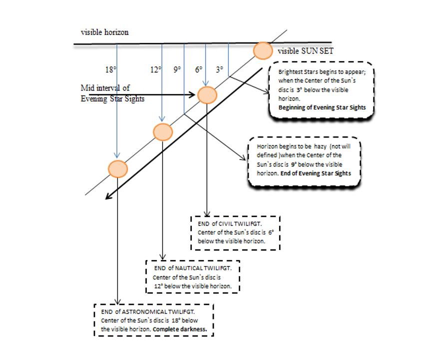
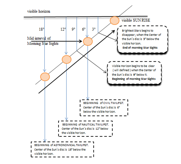
لذلك يجب توخى الحرص الشديد عند إستخدام هذه الطريقة فى خطوط العرض العليا وهو ما يتضح من الشكل التالى.
ففى خطوط العرض العليا تشرق الشمس أو تغرب بزاوية ميل صغيرة مع دائرة الأفق و من ثم فإن إتجاه الشمس البوصلى قد يختلف بقدر محسوس (0.5° → 1°.5) إذا لم يكن فى الوضع الصحيح ومن ثم يكون خطأ البوصلة غير دقيق.
الشكل التالى يوضح تسلسل الحل بطريقة السعة والتى تم على أساسها تصميم البرنامج
قم بتطبيقه الآن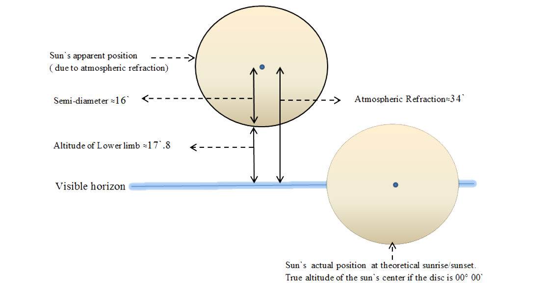
تعتبر مسألة الإعداد لرصد النجوم أثناء الشفق الصباحى أو الشفق المسائى من المهام الأساسية لضابط الملاحة ويتم الحساب على أساس أن منتصف فترة رصد النجوم هو بداية الشفق المدنى (Civil Twilight) صباحا أو نهايته مساءا
يتضح هذا من الشكل (1) لتتابع ظواهر شروق الشمس و الشكل (2) لتتابع ظواهر غروب الشمس.
حيث تم تصميم البرنامج على هذا الأساس.
وتكمن أهمية الإعداد لرصد النجوم فى أن الراصد لايستطيع فى الأغلب أن يتعرف على إسم النجم المراد رصده لأن النجوم قد لاتكون واضحة فى مجموعاتها النجمية صباحا بسبب تراكم السحب مثلا أو عدم إكتمال ظهور هذه المجموعات مساءا.
البرنامج الحالى يعطى خريطة لأفق الراصد فى وقت الشفق المدنى موضحا عليها النجوم الملاحية التى يحتمل رصدها وموضحا عليها أيضا خط سيرالسفينة بهدف توضيح الإتجاه النسبى لكل نجم بالنسبة لأجناب السفينة.
أيضا تعطى قائمة بأسماء تلك النجوم و إرتفاع و إتجاه كل منها بعد ذلك يختار الملاح النجوم التى سوف يقوم برصدها طبقا للأولويات التالية:
فى العديد من شركات الملاحة يتوجب على الملاح أن يرسل موقع السفينة فى وقت الظهر Noon position حيث يتطلب ذلك تنفيذ عدة خطوات هى:
True Lat. = T.M.Z.D. + / ~ Dec
يعتبر تحديد وقت جرينتش المتوسط ( لأقرب ثانية ) لحظة عبور الشمس على دائرة زوال الراصد مسبقا هو المشكلة ؛ فالشمس تتحرك على مدارها اليومى والسفينة تتحرك على خط سيرها ، فى نفس الوقت لذلك يلجأ الملاح لحساب وقت جرينتش المتوسط لحظة عبور الشمس على دائرة زواله بطريقة التقريب المتتالى وهو ما يتطلب العديد من خطوات الحل وبالتالى تزايد إحتمالات الخطأ وقد تم تصميم هذا البرنامج لتحديد وقت جرينتش الدقيق للمرور الزوالى للشمس بمساعدة المهندس إسلام بدوى ؛ لحل هذه المشكلة.
قم بتطبيقه الآن